![](/images/other/stat-length.png)
![Trail Horseback riding La Roche-sur-le-Buis - SityTrail - J3 lievre reilhanette 24k - Photo](https://media.geolcdn.com/t/1900/400/ext.pjpeg?maxdim=2&url=https%3A%2F%2Fstatic1.geolcdn.com%2Fsiteimages%2Fupload%2Ffiles%2F1524743154cheval.jpg)
SityTrail - J3 lievre reilhanette 24k
Helleni
User
![Length](/images/other/stat-length.png)
![Max alt](https://static1.geolcdn.com/siteimages/upload/files/1508320355ic_sort_altitude_max_24dp.png)
![Uphill gradient](https://static1.geolcdn.com/siteimages/upload/files/1508320355ic_sort_den_pos_24dp.png)
![Km-Effort](/images/other/stat-length.png)
![Min alt](https://static1.geolcdn.com/siteimages/upload/files/1508320355ic_sort_altitude_min_24dp.png)
![Downhill gradient](https://static1.geolcdn.com/siteimages/upload/files/1508320355ic_sort_den_neg_24dp.png)
![Boucle](https://static1.geolcdn.com/siteimages/upload/files/16400158638029165_repeat_loop_refresh_sync_direction_icon.png)
![Horseback riding](https://static1.geolcdn.com/sitytour/trail-icons/301.png)
4h04
Difficulty : Medium
![Scan this QR Code to open this trail in the SityTrail application](https://capi.geolives.com/qq0zvz2zws4bq2lad0pu/sitytour/trails/2223594/qr.png?size=200)
FREE GPS app for hiking
About
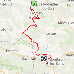
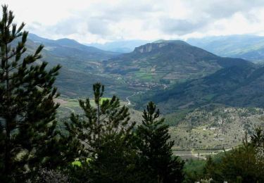
Trail Horseback riding of 24 km to be discovered at Auvergne-Rhône-Alpes, Drôme, La Roche-sur-le-Buis. This trail is proposed by Helleni.
Description
Le Tour Equestre GRP Pays de Dieulefit-Bourdeaux Il peut se faire dans sa totalité, de façon itinérante, par étape ou ponctuellement sur une partie du tracé. Des variantes existent permettant de modifier le circuit. Des variantes sont également disponibles au format .gpx sur simple demande. LE BALISAGE Conforme au cahier des charges de balisage de la FFE/CNTE, le tour équestre est marqué en orange. NB : Lorsque le tour équestre emprunte les étapes Mornans - Truinas, il est balisé en orange et bleu (Tradac Drôme à Cheval). Référence cartes IGN échelle 1/25 000 : 3038 E, 3138 OT, 3139 OT
Positioning
Comments
Trails nearby
![Trail Walking Le Poët-en-Percip - Le Poèt du Bout du Monde - Photo](https://media.geolcdn.com/t/375/260/1569e818-5455-4f23-8c9a-380b223c1c41.jpg&format=jpg&maxdim=2)
![Walking Walking](https://static1.geolcdn.com/sitytour/trail-icons/101.png)
Walking
![](/images/other/stat-length.png)
![](https://static1.geolcdn.com/siteimages/upload/files/16400158638029165_repeat_loop_refresh_sync_direction_icon.png)
![Trail Walking Aulan - 26 Aulan Poët en Percip - Photo](https://media.geolcdn.com/t/375/260/46c7bb6d-0b90-4bb1-97bc-ec1d2b520019.jpg&format=jpg&maxdim=2)
![Walking Walking](https://static1.geolcdn.com/sitytour/trail-icons/101.png)
Walking
![](/images/other/stat-length.png)
![](https://static1.geolcdn.com/siteimages/upload/files/16400158638029165_repeat_loop_refresh_sync_direction_icon.png)
![Trail Walking Sainte-Euphémie-sur-Ouvèze - 2024-04-21_15h22m31_26 Buis Petites-gorges-Ouvèze - Photo](https://media.geolcdn.com/t/375/260/50a924fc-c264-4be9-b1ba-9f2ef1fb0486.jpg&format=jpg&maxdim=2)
![Walking Walking](https://static1.geolcdn.com/sitytour/trail-icons/101.png)
Walking
![](/images/other/stat-length.png)
![](https://static1.geolcdn.com/siteimages/upload/files/16400158638029165_repeat_loop_refresh_sync_direction_icon.png)
![Trail Walking Sainte-Euphémie-sur-Ouvèze - Ste Euphémie- sur - Ouvéze 16 km. - Photo](https://media.geolcdn.com/t/375/260/01bea523-f1d0-4b3c-9ab3-81b6eb4ca226.jpg&format=jpg&maxdim=2)
![Walking Walking](https://static1.geolcdn.com/sitytour/trail-icons/101.png)
Walking
![](/images/other/stat-length.png)
![](https://static1.geolcdn.com/siteimages/upload/files/16400158638029165_repeat_loop_refresh_sync_direction_icon.png)
![Trail Walking Sainte-Euphémie-sur-Ouvèze - Ste Euphémie sur Ouvèze 15km - Photo](https://media.geolcdn.com/t/375/260/01620b9d-d313-4510-93cc-66e82aefda56.jpg&format=jpg&maxdim=2)
![Walking Walking](https://static1.geolcdn.com/sitytour/trail-icons/101.png)
Walking
![](/images/other/stat-length.png)
![](https://static1.geolcdn.com/siteimages/upload/files/16400158638029165_repeat_loop_refresh_sync_direction_icon.png)
![Mountain bike Mountain bike](https://static1.geolcdn.com/sitytour/trail-icons/202.png)
Mountain bike
![](/images/other/stat-length.png)
![](https://static1.geolcdn.com/siteimages/upload/files/16400158638029165_repeat_loop_refresh_sync_direction_icon.png)
![Trail Walking La Roche-sur-le-Buis - Tour de Bridons - Photo](https://media.geolcdn.com/t/375/260/ext.jpg?maxdim=2&url=https%3A%2F%2Fstatic1.geolcdn.com%2Fsiteimages%2Fupload%2Ffiles%2F1553511878bg_sport_marche.png)
![Walking Walking](https://static1.geolcdn.com/sitytour/trail-icons/101.png)
Walking
![](/images/other/stat-length.png)
![](https://static1.geolcdn.com/siteimages/upload/files/16400158638029165_repeat_loop_refresh_sync_direction_icon.png)
![Trail Walking Plaisians - De Plaisians à Brantes - Photo](https://media.geolcdn.com/t/375/260/ext.jpg?maxdim=2&url=https%3A%2F%2Fservices.sitytrail.com%2FGeolivesWS%2FDownloadMedia.ashx%3FTrailID%3D105349%26Media%3D9051_1.jpg)
![Walking Walking](https://static1.geolcdn.com/sitytour/trail-icons/101.png)
Walking
![](/images/other/stat-length.png)
![](https://static1.geolcdn.com/siteimages/upload/files/16400158638029165_repeat_loop_refresh_sync_direction_icon.png)
![Trail Walking Le Poët-en-Percip - Le Poët en Percip - Aulan - Montagne de la Bohémienne - Photo](https://media.geolcdn.com/t/375/260/ext.jpg?maxdim=2&url=https%3A%2F%2Fservices.sitytrail.com%2FGeolivesWS%2FDownloadMedia.ashx%3FTrailID%3D105312%26Media%3D9003_3.jpg)
![Walking Walking](https://static1.geolcdn.com/sitytour/trail-icons/101.png)
Walking
![](/images/other/stat-length.png)
![](https://static1.geolcdn.com/siteimages/upload/files/16400158638029165_repeat_loop_refresh_sync_direction_icon.png)